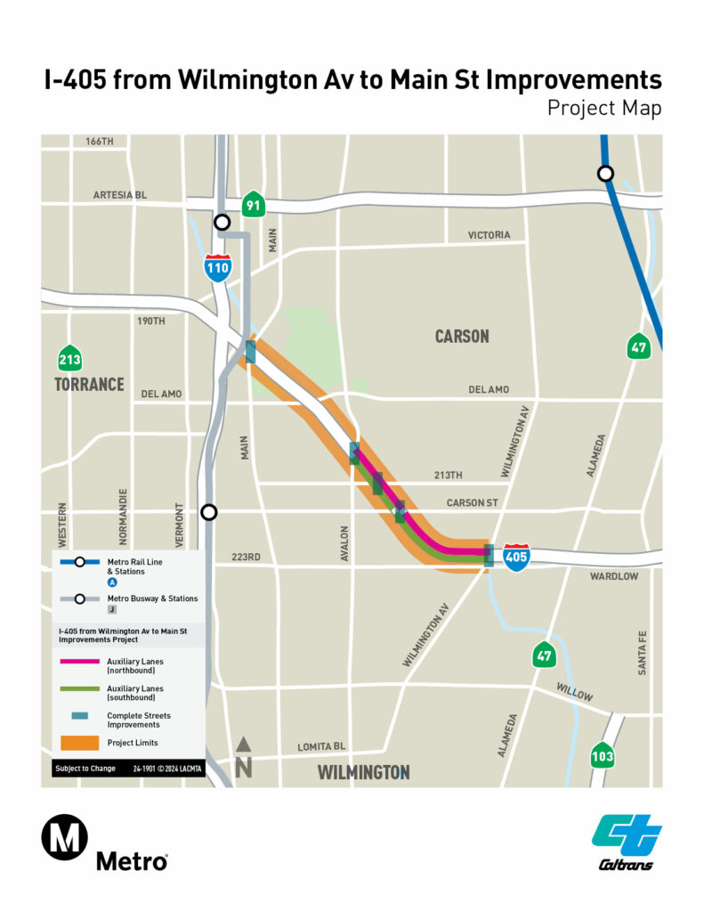
The project map outlines Metro and Caltrans’ proposed I-405 improvements between Wilmington Avenue and Main Street, including new auxiliary lanes and complete streets improvements through Carson and surrounding areas. / Photo Courtesy of Metro and Caltrans
Carson, CA — Metro and Caltrans are considering major safety and mobility improvements along a three-mile stretch of the I-405 Freeway between Wilmington Avenue and Main Street in Carson, with residents able to submit comments on the proposal through Sept. 21.
The corridor carries more than 300,000 vehicles daily and is considered one of the most congested portions of the I-405 in the Los Angeles area. Metro says the project is intended to improve traffic reliability and safety while providing better pedestrian and bicycle connections and supporting the movement of goods through the South Bay.
According to Metro, the project is still in the environmental review and early planning phase. Three alternatives are currently being studied.
The first would make no improvements. The second — the most extensive option — would add two auxiliary lanes in each direction of the freeway, along with Complete Streets improvements and traffic-management measures. A third alternative would include the Complete Streets and traffic-management elements but would not add auxiliary lanes.
Under Alternative 2, the proposed northbound auxiliary lanes would run between the Wilmington Avenue on-ramp and Carson Street loop off-ramp, and between the Carson Street on-ramp and Avalon Boulevard off-ramp. Southbound auxiliary lanes would be located between Avalon Boulevard and Carson Street and between Carson Street and Wilmington Avenue.
Auxiliary lanes are shorter lanes located between freeway entrances and exits that give drivers additional room to merge, weave or change speeds without adding new through lanes. Metro is also considering traffic-management tools such as ramp meters, vehicle-detection systems, signal synchronization, changeable message signs and turn-lane improvements.
The project would also include improvements on local streets intended to make travel safer for pedestrians and bicyclists. Those could include ADA-compliant sidewalks and curb ramps, additional bicycle facilities, upgraded crossings and improved lighting beneath freeway bridges.
Metro’s environmental documents indicate that construction under Alternative 2 could require short-term ramp closures and overnight freeway closures. The agency says freeway congestion and queuing would be slightly improved after construction, while bicycle and pedestrian circulation would also improve. Some on-street parking along 213th Street would be removed.
The environmental review also anticipates temporary construction-related noise, traffic and air-quality impacts, but states that neither build alternative is expected to result in significant and unavoidable impacts under the California Environmental Quality Act. No residential or business relocations or displacements are anticipated.
Metro held public hearings Aug. 20 and Aug. 25 at the Carson Events Center as part of the project’s 45-day public comment period.
Residents who did not attend the hearings can still submit comments through Monday, Sept. 21.
The environmental phase is being funded through voter-approved Measure R. Metro says future phases could rely on a combination of local, state and federal funding.
After public comments are reviewed, a final environmental document will be prepared that responds to comments and identifies a preferred alternative. The current project schedule anticipates release of the final environmental report in summer 2027.
Residents may submit comments or request project information by contacting the Metro project team at wilmington@metro.net or 310-854-3196.
I actually prefer this version to the earlier brief because now it tells readers exactly what Metro might build and what Carson could experience during construction, rather than simply announcing that a study is underway.
One especially good detail for the Compass is the 213th Street parking removal. That is precisely the sort of neighborhood-level impact that can get buried in a 20-plus-page environmental summary but matters to residents. I’d keep that in.